
Connor J. Thompson
The Canadian state began surveying the land in what would become Jasper Place in 1882. Lands formerly home to Indigenous peoples, and part of transportation networks and hunting grounds, were reworked as areas of habitation for mainly white settlers. While later periods of Jasper Place history are characterized by greater cultural diversity, the late nineteenth and early twentieth centuries were periods of mostly white settlement. Early settlement of Jasper Place followed patterns familiar to other parts of Alberta, though the landscape of the area and its proximity to what became a major urban centre – Edmonton – made Jasper Place’s development distinctive in several respects. This article surveys settlement in the area from the 1880s until the 1913 Depression, with some comment on the challenges Jasper Place would face in subsequent decades.
Note on terminology: I occasionally refer to the land south of today’s 118th Avenue, and bordered by 149 Street on the east and 170th Street on the west, simply as Jasper Place. But this article shows that the history of settlement is more uncertain and even amorphous than such terminology suggests. The name “Jasper Place” was not attached to the area until 1906, and these boundaries were only solidified in 1949 when the village of West Jasper Place was incorporated.
Dominion Land Survey and First Settlers
The Dominion Land Survey was a massive reimagining and reworking of Indigenous territory, which eliminated existing land use patterns and mapped the land in a way that privileged private property and agricultural settlement. A massive grid network was utilized by the Canadian state, based mainly on 640-acre sections which were quartered into 160-acre parcels. First Nations reserves, colonization company bloc settlements, and national parks were some exceptions to this pattern.
The Survey was administered by the 1872 Dominion Lands Act. The Act reflected the Canadian government’s intention to facilitate agricultural settlement of the Prairies through the homesteading system, as well as its commitment to administer the huge land grants promised to the Canadian Pacific Railway and Hudson’s Bay Company. While the grid pattern dominated, the realities could be quite different at the local level. Surveyors encountering existing residents sometimes had to resolve land disputes quite spontaneously – often favouring white over Indigenous land claims.[i] We see these tensions – between high-level political desires and on-the-ground realities – in the region around Fort Edmonton. The immediate area around Fort Edmonton was initially surveyed according to a river lot pattern, reflecting the traditional agricultural patterns of the Métis. Chief Papaschase, whose people had asked for their reserve on the south banks of the North Saskatchewan River in present-day Strathcona, was forced to locate it farther south. Eventually, the reserve was lost altogether, following a long-term racist campaign against the Cree led by Frank Oliver.[ii]
In other parts of the region, surveying followed the grid pattern, and this was applied in the land which became Jasper Place. The earliest government-approved survey in the area was conducted in 1882 by Walter Beatty, whose crew included Indigenous workers and hired settler labourers.[iii] The following year, these lands were made available for settlement. After surveying was complete, some existing residents were able to secure their place on the land.
Early Settlers
In 1886 Henry and Fanny Goodridge applied for 320 acres of land where they had already been living for some time. Henry, a former soldier, had moved to the area in 1876 by harsh and demanding overland travel.[iv] Fanny arrived in 1882 on the Northcote steamer, leaving her home of Clinton, Ontario. Travel on the Northcote was quite an event for her, and is often recalled in subsequent reminiscences. Fanny and Henry were married in a Presbyterian ceremony that summer, and the couple was well-respected in the community – at her death in 1932, she is described as being mourned by “a big circle of friends.”[v] Their land was located immediately next to the Stony Plain Trail, which became Stony Plain Road. Mr. and Mrs. Goodridge became involved in the Edmonton Old Timers’ Association (later the Northern Alberta Pioneers and Old Timers’ Association), joining when it was founded in 1884. Henry also served on Edmonton’s Town Council.
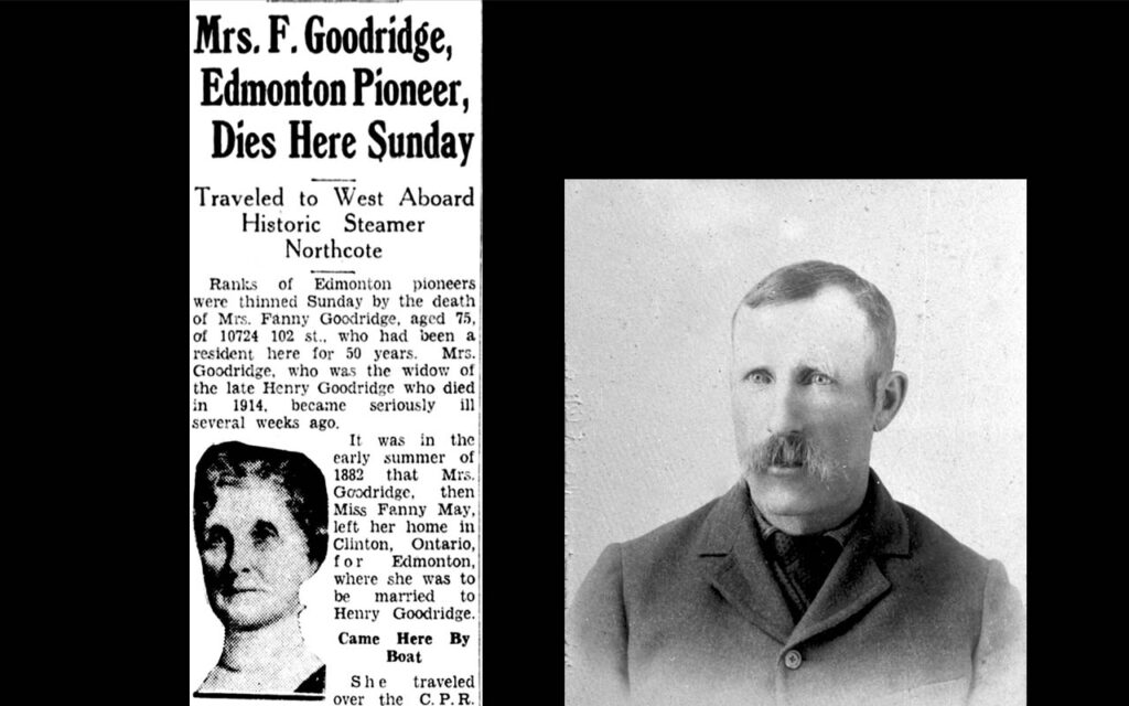
Right: Henry Goodridge, 1880. Courtesy of City of Edmonton Archives, EA-10-689-44. Creator: Northern Alberta Pioneers and Old Timers’ Association (NAPOTA).
The Goodridges settled on land immediately next to their friends, the McKays. Donald Spence McKay arrived at Fort Saskatchewan in 1881, having also travelled to the Edmonton area via an overland route. For most of the trip, he used a wagon pulled by a team of four oxen. Previously a merchant, he was middle-aged when he located the family’s home in the Jasper Place area. Mrs. McKay arrived on the Northcote with Fanny Goodridge, travelling with two children – daughter Birdie and son Gilbert. The family settled on their Jasper Place land in 1882, and the couple later welcomed a third child in 1887. The continued warmth between the Goodridges and McKays is suggested by Henry Goodridge acting as witness when McKay filed for patent on his land in 1886. The two couples farmed next to one another for a decade.[vi] To the southeast, bootlegger and future Indian Agent James Gibbons lived with his wife Mary Isabelle and their five children near the shore of the North Saskatchewan River, having settled on that land in 1878. To the east, the McKay’s farm bordered on the property of Malcolm Groat, a Scottish former Hudson’s Bay Company employee whose large estate was surveyed as River Lot 2. The Groat family included Margeurite, Malcolm’s wife, and nine children.[vii]
Another early farm was the home created by Thomas and Catherine (née Bruneau) Logan, who settled on land north of the Goodridges. Thomas’ brother, Robert, and Robert’s wife Maggie, also settled in the Edmonton area. Thomas Logan was Métis, the child of Thomas Logan Sr. and Mary Ann Dease of Red River, Manitoba. The extended Logan family was quite influential and had vast connections across the Prairies. Thomas and Catherine had a son named John William Logan, and the family established a modest farm which included horses and cattle. Logan was an old man by the time he settled in the area. He had initially filed on an entire section, but when he died in 1892, the family only held patent to the southwest quarter section. This left sixty-two-year-old Catherine and her son inheritors of the farm, which by then had increased tremendously in value. They eventually sold the land in the early twentieth century.[viii]
Aside from these families, many early settlers in the area were unmarried. As late as 1911, Alberta had as many as 86,043 single men living in the province but only 24,189 single women, and over 70,000 more men than women in the overall population.[ix] The gender imbalance occurred partly because of Canadian homestead regulations, which prevented most women from filing on homesteads. The rare exceptions were usually widows.[x] Unlike the United States, opportunities for single people to homestead were almost universally reserved for men. Writing to family in the late 1880s, Jasper Place-area settler Herbert Stringer described himself as the only bachelor in the area, with all of his neighbours either married or soon-to-be married. He cautioned his extended family that any more young men seeking to homestead should marry before traveling to the Prairies, as women were few and bachelors many.[xi] Taking advantage of the supposed “freedom” homesteading offered, John Duhamel arrived in the Jasper Place area as a single man, a miner from British Columbia who ended up with some of the swampiest land in Jasper Place. Having located his quarter section in 1899 at the age of 22, Duhamel managed to build a house that fall and had ten head of cattle. However, he was affected by the vagaries which often frustrated settlers: he could do little to cultivate the marsh that comprised much of his homestead and so, to make ends meet, he was forced to return to B.C. to work in the mines. Duhamel returned to his land two years later and eventually applied for patent in 1906, seeing opportunities for subdivision and sale.[xii]
Many other early settlers obtained their properties from the Canadian Pacific Railway land grants, which were gradually sold off over the late nineteenth and early twentieth centuries. The CPR was given 25,000,000 acres of land on the Canadian Prairies to subsidize the building of the railway, and over time the Company’s land sales activities became essentially as important as their railway operations. The Company was allowed to select any odd-numbered sections in surveyed lands and could refuse lands which were not considered “fairly fit for settlement” (an option they mainly took in the Dry Belt of the southern Prairies). In the Jasper Place/then-west Edmonton area, the CPR availed themselves of nearly all odd-numbered sections. On the land in 53-25-W4M (the CPR section which became the subdivision of Britannia-Youngstown), the population more than doubled in ten years, from 195 people in 1901 to 448 by 1911.[xiii]
While these early settlers formed the beginnings of a community in the area, substantial settlement occurred slowly. The boom in Strathcona real estate, caused by the arrival of the Calgary-Edmonton Railway, and the existing community on the north side of the river delayed Jasper Place becoming the site of concerted settlement until the middle of the 1900s.[xiv] The name Jasper Place seems to have been first attached to the subdivision created by Roy F. Likely in 1906, who had neighbouring quarter sections along present-day Stony Plain Road. The name originated for the same reasons Jasper Avenue was given its appellation: the well-known trapper, Jasper Hawes, whose name was attached to Jasper’s House, Jasper Lake, and the town of Jasper.[xv] Only a year later, the Goodridges had their land subdivided and began advertising it as “North Jasper Place,” fixing the term to the area. Sales in the newly created subdivision were quite successful and enabled the Goodridges to invest in other land in the vicinity of Edmonton.[xvi] The presence of the Stony Plain Trail and the eventual arrival of railways through the area made it a desirable neighbourhood. Oft-remarked in advertising on the area was the high elevation and relative proximity to the river.
Speculators
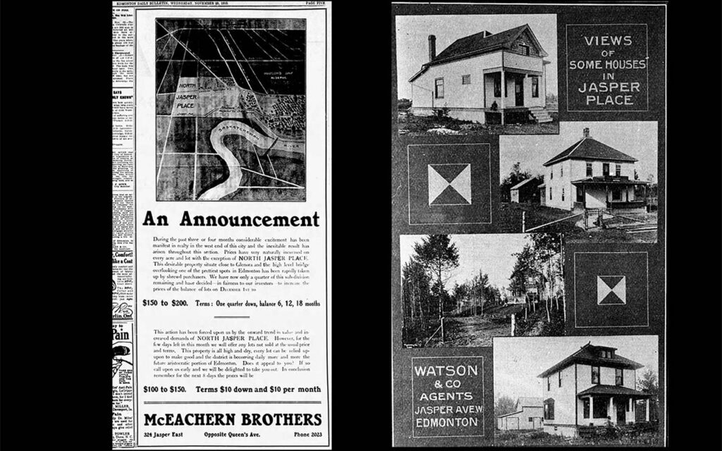
Jasper Place was subject to the feverish “boosterism” of the turn-of-the-century period – a phenomenon of nascent Prairie communities attempting to attract investment, railway extensions, and settlers by extolling the unlimited potentiality of their communities.[xvii] While boosterism was often in the interests of those living and working in the municipality in question (it is a lot easier to sell one’s grain if a railroad is attracted to the area!), it could also be, and frequently was, a guileful moneymaking scheme. Speculation was incentivized by a variety of factors, some of which were present in Jasper Place: the proximity of the land to the fledgling cities of Edmonton and Strathcona certainly made unlimited growth seem real. In earlier times, the promise of Western communities was said to lie in the excellent agricultural prospects or the chance for a new life on a homestead. In 1906, the Edmonton Journal wrote that Jasper Place lands offered, not excellent agricultural prospects or the chance for a new life on a homestead, but “[o]pportunities for money making.”[xviii] Such language was exactly how real estate companies advertised properties in the area: Watson & Company called Jasper Place lots “a sure Money-Maker.”[xix] McEachern Brothers called North Jasper Place “the future aristocratic portion of Edmonton,” and encouraged buyers to act immediately, as three quarters of the subdivision had already been “rapidly taken up by shrewd purchasers.”[xx]
Some landowners in what became Jasper Place were speculators with no interest in settling on the land themselves. One was Judge Charles B. Rouleau, who was most famous for having tried Wandering Spirit’s (Kapapamahchakwew) case after the North West Resistance. Rouleau had suffered personal losses during 1885, including the destruction of his home. Thus, his trials of Resistance participants were tinged with personal animosity. Rouleau was quoted in the Saskatchewan Herald as saying that “every… rebel brought before him after the insurrection was suppressed, would be sent to the gallows if possible.”[xxi] Rouleau’s career as a judge led him to move to Calgary in 1889, where he began expanding his investments. He acquired his Jasper Place land, a 240-acre parcel, the year after his move to Calgary.[xxii] Though he had investments in Edmonton (he was owner of the Edmonton Gold Mine), these seem to have been purely monetary ventures, and there is no evidence that Rouleau ever intended to become resident in the area. These investments did not all go well. According to historian Louis A. Knafla, when Rouleau passed away, he “owed money to almost every bank in Canada.”[xxxiii]
For others, however, speculation proved wildly lucrative. Albert Cleland amassed a small fortune partly through numerous substantial sales in the Edmonton and Jasper Place area. In 1911, he made a $40,000 land sale just west of Jasper Place, amounting to $250 an acre.[xxiv] Even after he had moved away to Nanaimo, British Columbia, he continued selling tens of thousands of dollars of real estate in Edmonton.[xv] Cleland had significant landholdings in Jasper Place in what later became the subdivision of West Lawn. After he passed away in 1921, his estate was in the process of dealing with this land, which was still being subdivided.[xxvi] Roy F. Likely, whose initial subdivision was named Jasper Place, also owned other property in Alberta; while living in Vancouver, B.C., he was advertising a section of land in the Ranfurly area.[xxvii]
While individuals such as Cleland and Likely profited from the speculative sale of Jasper Place land, they were hardly alone. Real estate firms purchased many of the lots in Jasper Place, either selling the bare land or lots themselves, or in some cases building homes and infrastructure to incentivize sales. Alberta Investments Ltd., founded in 1911 amidst a frenzy of land sales,[xxviii] acquired most of the land west of the Goodridge’s old homestead in 1912 to create the subdivision of Brittania. The Edmonton Investment Company created the Lorne Park subdivision around the same time.[xxix] The Bremner Estate, which was created out of the former land of the Logans, was selling lots in 1912 for $225 an outside lot, and $300 a corner lot. While a fine price, in the nearby subdivisions of Jasper Place and North Jasper Place property was becoming very desirable given its proximity to the railroad. Real estate firm Bagley, Logan & Archer were asking $900 a lot that same year in the Jasper Place subdivision, while F. Fraser Tims was asking a whopping $5,000 for ten lots in North Jasper Place.[xxx]
Subdivision, farmland, and the challenges which followed the 1913 Depression
By 1912, many subdivisions had been established in Jasper Place, which was then part of Local Improvement District No. 519. Aside from those mentioned above, Dufferin Place, West Lawn, and Balmoral were established amidst the explosion of new subdivision which occurred at the beginning of the 1910s. A significant addition to Lorne Park was also undertaken in 1912.[xxxi] This activity, fuelled partly by the arrival of more settlers to this area, and partly by an economic boom across Canada as a whole, led to a massive increase in land prices.[xxxii] Homebuilding proceeded quite quickly, along with the creation of roadways and the formation of a school district. The Edmonton Bulletin wrote that Jasper Place would rapidly become one of the area’s “most fashionable dwelling sites.”[xxxiii]
The pattern of Edmonton’s growth was not inevitable. Early in the area’s history, relationships between the fledgling city of Edmonton and the area that became Jasper Place were simply a matter of course: the Stony Plain Trail, especially, meant that a sense of distinctiveness between “Edmonton” and its immediate neighbors was far from established. However, once concerted subdivision began and the question of how to provide municipal services became pressing, boundaries were suddenly an important issue. The border between Edmonton and what became Jasper Place was defined as today’s 149th street in 1913, on what was once the McKay’s property. The former Goodridge farm was now divided from the former McKay farm, which sat just inside Edmonton’s western border.[xxxiv] But even as all this activity was occurring, those living in Jasper Place continued to utilize the land for agriculture. Jasper Place land was occasionally still advertised for its agricultural potential, especially in places further from the main arterial roads and railways. Even as the area was being subdivided and sold for land development, “North Jasper Place chicken” was featured on the menu of Gibson & Company’s 1906 annual dinner.[xxxv] However, much of this property was imagined and advertised as a future thriving subdivision. During the peak years of 1911/1912, Watson & Co. began handling sales of many lots in North Jasper Place and undertook the building of sidewalks.[xxxvi]
Right: Detail of p. 190, Edmonton Bulletin, Special Edition 1911. Courtesy of City of Edmonton Archives, ED-26-397
All of this came crashing down in 1913, which one historian described as “the pivotal event in Edmonton’s civic history.”[xxxvii] An international depression partly caused by tightening credit due to pre-World War I tensions, the economic contraction which began in 1913 hit emerging Prairie communities especially hard. Across the region, plans for city expansion were cancelled, unemployment skyrocketed, and for many, the period was devastating. By Christmas of 1913, a 1,000-person hunger march of unemployed men took place in Edmonton.[xxxviii] In Calgary, between 1912 and 1913, building permits fell by more than half, and over a third of the male workforce was unemployed.[xxxix] These same issues affected Jasper Place, an area which had just begun the subdivision process and which had few non-transients. Work was sparse, and many had to move to find it. The Britannia-Youngstown and Canora subdivisions experienced a population drop of nearly 40% between 1911 and 1916 which was no doubt partly due to the First World War effort, but some of which would have been a more direct result of the Depression.[xl] The spirit of the time can be aptly summarized by a desperate 1914 advertisement listed in the Edmonton Bulletin classifieds section: “A SACRIFICE – Two of the best lots in west end. High, dry and level. Value $700. (North Jasper Place.) Will sell $100 cash.”[xli]
The community would not experience significant expansion again for some time, and the subdivisions of Lorne Park and West Lawn were simply cancelled in the 1920s.[xlii] Jasper Place had limited public services, and the Local Improvement District it was situated within did not have the tax base to maintain, let alone build, services for its residents. This meant that the people of Jasper Place had to provide, as much as possible, for themselves. Well into the twentieth century residents maintained large gardens, hunted small game, and had substantial spaces for burning their own garbage – evidence of how the people of Jasper Place made ends meet however they could. Given the post-World War I recession and later the Great Depression, population expansion was mostly limited to Edmontonians fleeing the city’s comparably high tax rates. Residents of Jasper Place had to prioritize self-sufficiency for many years. Many did this by raising livestock and engaging in small-scale farming throughout the 1920s and 1930s, continuing these sorts of land use patterns as a means of providing for themselves.[xliii]
 Plan of Township 53, Range 25, West of the Fourth Meridian, Alberta, May 9, 1912. Courtesy of the Provincial Archives of Alberta, PR1979.0269.0103g. Note: W. Beatty first surveyed this area in 1883.


Notes
[i] In the Edmonton area, see the discussion of Randy Lawrence in “Metis Strathcona” in Tom Monto, Old Strathcona: Edmonton’s Southside Roots (Edmonton: Crang Publishing, 2011).
[ii] About which see Dwayne Trevor Donald, “Edmonton Pentimento: Re-Reading History in the Case of the Papaschase Cree” Journal of the Canadian Association for Curriculum Studies 2, no. 1 (2004), https://doi.org/10.25071/1916-4467.16868 For broader context, see Bill Waiser and Jennie Hansen, Cheated: The Laurier Liberals and the Theft of First Nations Reserve Land (Toronto: ECW Press, 2023).
[iii] Donald Luxton and Associates, Inc., “Jasper Place Historic Resources Inventory.” (Edmonton: City of Edmonton, 2019), 17.
[iv] Edmonton Bulletin [hereafter EB], Feb. 26, 1914, “Death Takes Places of H. Goodridge.”
[v] Edmonton Journal [hereafter EJ], Aug. 2, 1932, “Mrs. F. Goodridge, Edmonton Pioneer, Dies Here Sunday,” 11.
[vi] Acc. No. 1970.313 Microfilm reel 2001 File 80796, Provincial Archives of Alberta, Edmonton [hereafter PAA]; EB, Mar. 19, 1887, “Births,” 4; EJ, Aug. 2, 1932, “Mrs. F. Goodridge, Edmonton Pioneer, Dies Here Sunday,” 11; EJ, Sept. 1, 1955, “By River Steamer, Ox Cart, Pioneers Arrived in ’82 to Unforeseen Hazards.”
[vii] Edmonton Historical Board, “Glenora,” accessed Apr. 28, 2025, https://www.edmontonhistoricalboard.com/neighbourhoods/glenora/
[viii] Information in this paragraph comes from GR1995.399 Box 67 File 2291, “Thomas Logan,” Provincial Archives of Alberta, Edmonton [hereafter PAA]; GR1995.0399 Box 236 File 6596, “Robert Logan,” PAA; RG15-D-II-8-j, Volume number: 1415, File number: 599162 “Logan (née Bruneau), Catherine, heir to Thomas Logan,” Library and Archives Canada [hereafter LAC]; RG15-D-II-8-c, Volume number: 1356, Microfilm reel number: C-14985 “Logan, John William,” LAC.
[ix] Canadian Bureau of Statistics, Census of Prairie Provinces, 1916 (Ottawa: King’s Printer, 1918), xxvi.
[x] Sarah Carter, Imperial Plots: Women, Land, and the Spadework of British Colonialism on the Canadian Prairies (Winnipeg: University of Manitoba Press, 2016).
[xi] PR1985.0002, Herbert Stringer fonds, PAA.
[xii] Acc. No. 1970.313 Microfilm reel 2056 File 531371, PAA.
[xiii] Bureau of Statistics, Census 1916, 92.
[xiv] On this, see the work of John F. Gilpin – “Failed Metropolis: The City of Strathcona, 1891–1912” in Town and City: Aspects of Western Canadian Urban Development ed. Alan F. J. Artibise (Regina: Canadian Plains Research Center, 1981), 259–288; “Urban Land Speculation in the Development of Strathcona (South Edmonton)” in The Developing West: Essays on Canadian History in Honor of Lewis H. Thomas ed. John E. Foster (Edmonton: The University of Alberta Press, 1983), 179–199; “The Edmonton and District Settlers’ Rights Movement, 1880–1885” in Swords and Ploughshares: War and Agriculture in Western Canada ed. R. C. Macleod (Edmonton: The University of Alberta Press, 1993), 149–172.
[xv] City of Edmonton Heritage Sites Committee, Naming Edmonton: From Ada to Zoie (Edmonton: University of Alberta Press, 2004),165.
[xvi] Many of these investments did not go well. At the death of Fanny Goodridge in 1934, the Goodridge Estate owed approximately $8,000 on a mortgage and another one of their properties was forfeited to the City of Edmonton for taxes. The investments Henry had made in various stocks had resulted, in the worst case, in a complete loss. GR1995.0399 Box 138 File 4280, “Henry Goodridge,” PAA.
[xvii] On boosterism, Alan F. J. Artibise, ed., Town and City: Aspects of Western Canadian Urban Development (Regina: Canadian Plains Research Center, 1981) remains a good introduction to the subject.
[xviii] EJ, Aug. 13, 1906, “Provincial and General,” 6.
[xix] EJ, Aug. 8, 1906, “Jasper Place,” 3.
[xx] EB, Nov. 23, 1910, “An Announcement,” 5.
[xxi] Saskatchewan Herald, Dec. 14, 1885, “Judging a Judge.”
[xxii] RG15-D-II-8-1, Vol. 1436, item 5895, “Whitford, Simon Peter land sale to Rouleau, Charles B., Aug. 1890,” LAC.
[xxiii] Louis A. Knafla, “ROULEAU, CHARLES-BORROMÉE,” in Dictionary of Canadian Biography, vol. 13, University of Toronto/Université Laval, 2003–, accessed April 11, 2025, https://www.biographi.ca/en/bio/rouleau_charles_borromee_13E.html.
[xxiv] EB, Mar. 15, 1911, “The Real Estate Market,” 1.
[xxv] In one sale alone, he made a reported $42,500, EB, June 12, 1913, “Around the City,” 9.
[xxvi] EB, Jan. 13, 1921, “In the Matter of An Act Respecting Subdivisions,” 2.
[xxvii] EB, Aug. 26, 1918, “For Sale – Section of Land,” 8.
[xviii] Edmonton Bulletin Special Edition 1911 p. 148, https://cityarchives.edmonton.ca/1911-edmonton-bulletin-special-edition
[xxix] Luxton and Associates, “Jasper Place,” 18.
[xxx] EB, Mar. 20, 1912, “Bremner Estate,” 8; EB, Mar. 20, 1912, “F. Fraser Tims,” 12.
[xxxi] Luxton and Associates, “Jasper Place,” 7.
[xxxii] EB, Mar. 15, 1911, “The Real Estate Market,” 1; EB, Apr. 18, 1912, “Sound Investments,” 7.
[xxxiii] Edmonton Bulletin 1911 Special Edition, “Watson & Co.,” 190.
[xxxiv] Luxton and Associates, “Jasper Place,” 18–19.
[xxxv] EB, Aug. 3, 1906, “Gibson & Co.’s Annual Dinner,” 1.
[xxxvi] Edmonton Bulletin 1911 Special Edition, “Watson & Co.,” 190.
[xxxvii] John C. Weaver, “Edmonton’s Perilous Course: 1904 – 1929,” Urban History Review/Revue d’Histoire Urbaine 2 (Oct. 1977), 21.
[xxxviii] Weaver, “Edmonton’s Perilous Course,” 31.
[xxxix] David Bright, The Limits of Labour: Class Formation and the Labour Movement in Calgary, 1883–1929 (Vancouver: UBC Press, 1998), 100–101.
[xl] Bureau of Statistics, Census 1916,92.
[xli] EB, June 12, 1914, “A Sacrifice,” 8.
[xlii] Luxton and Associates, “Jasper Place,” 18.
[xliii] Luxton and Associates, “Jasper Place,” 8, 18–19.
Connor J. Thompson is a PhD Candidate in History at the University of Alberta. Thompson’s writing on various aspects of Edmonton history can be found in Prairie History, Alberta History, the Edmonton City as Museum Project, the Canadian Historical Association’s magazine Intersections, and the Edmonton Heritage Council blog. He is also the editor of The Engagement Letters of Marie Harwood and Sam Steele, Oct. 1888–June 1889, which was published in 2023 by the Historical Society of Alberta.