Sarah Carter
What did it mean to homestead? We think of the term today as synonymous with farming, or generally establishing a home in a rural area. But in Western Canada (and the U.S. West) the word “homesteader” had a much more specific meaning. It meant that you were located on a free grant of 160 acres (or one quarter section) that was land administered by the federal government. You paid $10.00 to legally locate there, and you then had to cultivate and live on the land before you legally owned the land. While by no means entirely “free” given the costs involved in establishing a farm, it was much cheaper than purchasing land.
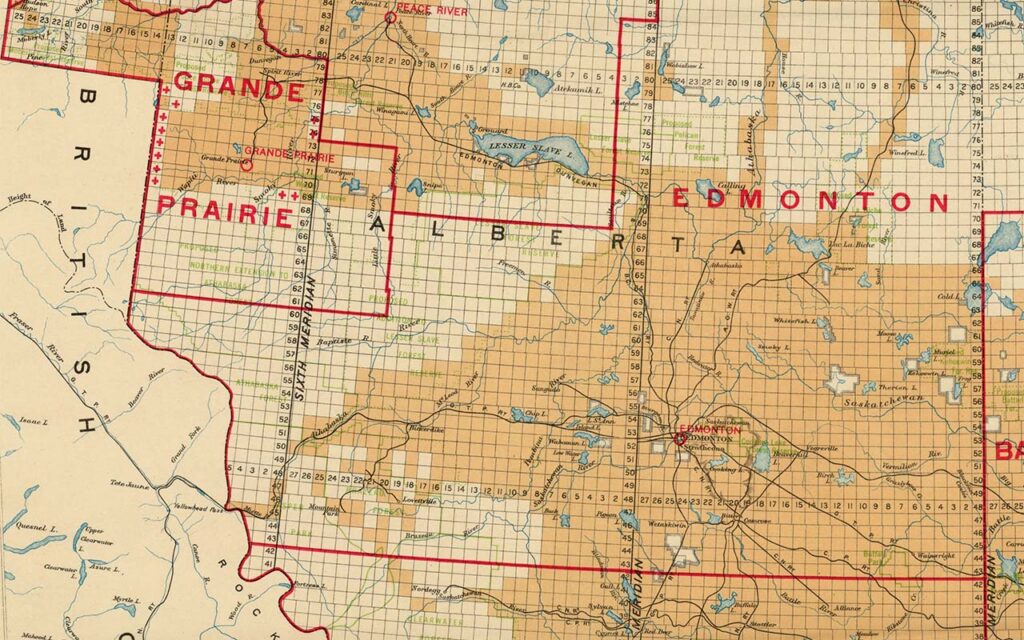
The Dominion Land Survey: All of the land in the Northwest Territories, with the exception of the “postage stamp” province of Manitoba was under the control of the federal government after 1870. The survey that began in 1871 affirmed Canadian sovereignty over these lands, and facilitated non-Indigenous settlement. The land was surveyed into square townships of 36 square sections. Each section was one mile square and consisted of 640 acres each. Sections were further subdivided into four quarter-sections of 160 acres each. Township lines run east and west and were numbered north from the international boundary. The lines that run north and south are Range lines. The First or Principal Meridian in Manitoba was located just west of Winnipeg and additional meridians were added as the survey advanced west. For example the Fourth Meridian forms the Saskatchewan-Alberta border and bisects Lloydminster.
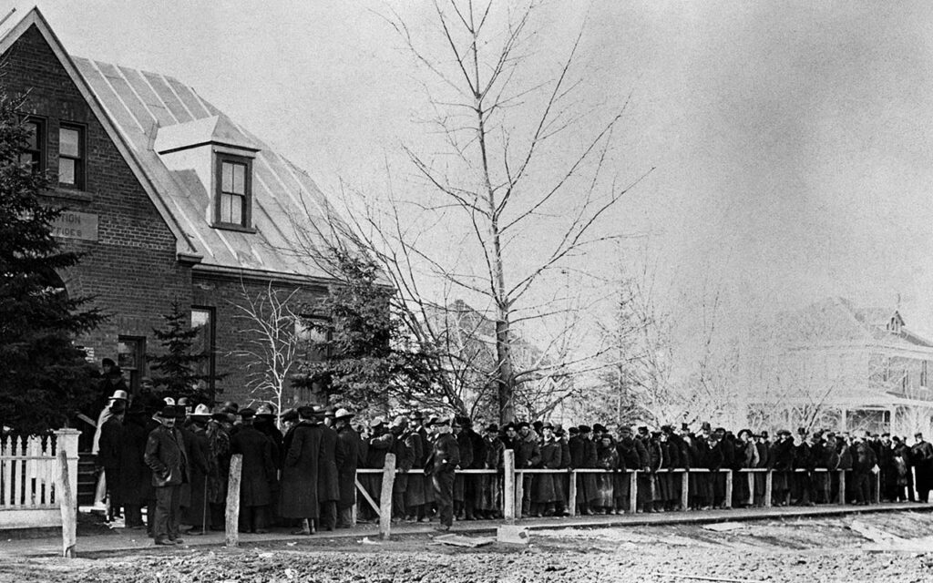
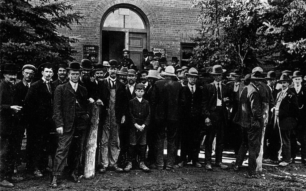
Administration of Land: In 1871 the Dominion Lands Branch, a branch within the Department of the Interior, was created to administer the 1872 Dominion Lands Act. There were Dominion Land Offices in towns and cities of the West, employing agents, sub—agents and homestead inspectors.
Special Sections: The odd-numbered sections in each township were railway land grants. The Canadian Pacific Railway was granted 25,000,000 acres. The Hudson’s Bay Company was awarded 1 and 3/4 sections in each township. Two sections in each township were set aside to support educational facilities and were called school sections. Railway, Hudson’s Bay Company and school lands were available for purchase, and the idea was that as the homesteaders improved their quarter-sections they would seek to expand through purchase. The value of the land would increase as the homesteaders improved the land, and other buyers would also be enticed. These sections could also be available for leasing.
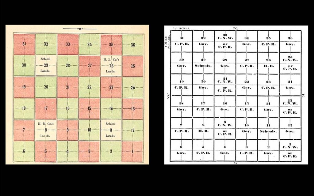
Right: Drawing of a Township, Canadian Pacific Railway. Land map of Manitoba and Canadian North West. [Montreal- CPR], 1899, via Archive.org.
Entry on a Homestead: The even-numbered sections in each township were available as homesteads under the Dominion Lands Act. The homesteader paid a $10.00 filing fee and chose a quarter-section (160 acres). A variety of terms were used for this process: the homesteader filed on, or claimed, or made entry on a homestead, generally in person at the local land office. Homesteaders often found the land unsuitable and the filled out a Declaration of Abandonment that specified why they were unable to farm or reside on that land, and they were free to file on another quarter-section.
Who could claim a homestead?
● Under the Indian Act (1876) no one who was “Indian” could homestead.
● Before 1874 any single woman or any male over the age of 21, and this was changed in 1874 to 18 years of age.
● In 1876 entry could be made by any person who was a sole head of a family, or any male over the age of 18. Single women were no longer permitted to homestead. A woman could homestead only if she was a sole head of household with a minor child or children. This was interpreted to mean a widow.
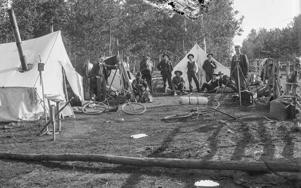
Proving Up: After filing on a quarter-section, homestead duties had to be performed for a minimum of three years (and in many cases the process took longer.) This process was known as proving up. Duties included residence and cultivation on the homestead to prove that he or she was a bona fide settler. In each year for three years the homesteader had to reside for at least six months on the homestead and cultivate the land.
Application for Patent: At the end of three years, if the homesteader fulfilled all of these duties, she or he gave six months’ notice in writing of intention to apply for patent. The homesteader filled out an application for patent, clear title, or outright ownership, that contained information on the applicant and family, including nationality and proof of naturalization, and details on breaking/cropping, livestock, and buildings. Two witnesses, usually neighbours, were required to attest to the truth of the application. Application was made before the local land agent or homestead inspector. If the application was approved, a patent would be issued to the homesteader who was then the owner of the land.
Pre-emption: From 1874 a homesteader could obtain a second quarter section of land adjacent to the homestead. At the time of filing on a homestead, the settler could also claim a pre-emption (for an additional $10.00 filing fee). The homesteader had the right to purchase that land after receiving patent to the homestead and was given three years to make that purchase. Pre-emptions were cancelled in 1890 and restored in 1908, when cultivation requirements were added.
Purchased Homesteads: Between 1871 and 1918, a settler could purchase 160 acres of land within a nine mile radius of his or her homestead at $3.00 per acre.
Notes: Advertised as “free” homesteads available to all, this was far from the case. Estimates of farm-making costs vary. Historian Lyle Dick analyzed farm-making costs between 1882 and 1914 and divided his findings into three categories. The minimalist farmer required $291 to $564; the average farmer required between $590 and $1,193; and the substantial farmer between $2,093 and $5,873.[i]
Nor were all potential homesteaders welcomed to the Canadian prairies. Single settler women were not permitted to homestead (unlike in the U.S. West where many single women homesteaded). Under the Indian Act no one who was “Indian” could homestead. African Americans from Oklahoma sought homesteads and equality on the Canadian prairies between 1905 and 1912. Over one thousand migrated settling in Saskatchewan and Alberta, yet they faced racism in their new setting and Canada took steps to discourage further immigration of African Americans.[ii]
Canada’s Department of the Interior, and the Canadian Pacific Railway sought to attract white, male settlers to farm the Prairie West, preferably from Great Britain and the United States from the late 19th century to the 1920s. Colourful, enticing posters depicted the West as a land of idyllic plenty where land was free. They conveyed the image that the land was empty before settlers arrived, not mentioning or depicting Indigenous Peoples, or indicating that treaties with First Nations promised that the land and resources were to be shared.
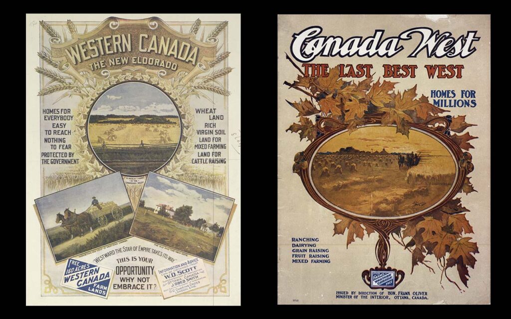
Right: Poster encouraging immigration to Western Canada, 1905-1911. Courtesy of the Provincial Archives of Canada, A5135b.
References
[i] Lyle Dick, “Estimates of Farm-Making Costs in Saskatchewan, 1881 – 1914,” Prairie Forum, v. 6 (1981): 113.
[ii] R. Bruce Shepard, Deemed Unsuitable, Toronto: Umbrella Press, 1997.
The document, Homestead Records, from the Provincial Archives of Alberta is a guide to doing research about homesteaders in Alberta.
Further Reading
Allen, Douglas W. “Homesteading and Property Rights: Or, ‘How the West Was Really Won.’” Journal of Law and Economics 34, no. 1 (April 1991): 1–23.
Belich, James. Replenishing the Earth: The Settler Revolution and the Rise of the Anglo-World, 1783–1939. Oxford: Oxford University Press, 2009.
Carter, Sarah. “Erasing and Replacing: Property and Homestead Rights of First Nations Farmers of Manitoba and the Northwest, 1870s–1910s.” In Place and Replace: Essays on Western Canada, edited by Adele Perry, Esyllt W. Jones, and Leah Morton, 14–39. Winnipeg: University of Manitoba Press, 2013.
Dick, Lyle. Farmers “Making Good”: The Development of Abernethy District, Saskatchewan, 1880–1920. Ottawa: National Historic Parks and Sites, 1989.
Friesen, Gerald. The Canadian Prairies: A History. Toronto: University of Toronto Press, 1984.
Lambrecht, Kurt N. The Administration of Dominion Lands, 1870–1930. Regina: Canadian Plains Research Centre, 1991.
Shepard, R. Bruce. Deemed Unsuitable: Blacks from Oklahoma Move to the Canadian Prairies in Search of Equality in the Early 20th Century Only to Find Racism in Their New Home. Toronto: Umbrella Press, 1997.
Smith, Keith C. Liberalism, Surveillance, and Resistance: Indigenous Communities in Western Canada, 1877–1927. Edmonton: Athabasca University Press, 2009.
Tough, Frank, and Kathleen Dimmer. “‘Great Frauds and Abuses’: Institutional Innovation at the Colonial Frontier of Private Property: Case Studies of the Individualization of Maori, Indian and Metis Lands.” In Settler Economies in World History, edited by Christopher Lloyd, Jacob Metzer, and Richard Sutch, 205–49. Leiden, Boston: Brill, 2013.
Weaver, John. The Great Land Rush and the Making of the Modern World, 1650–1900. Montreal: McGill-Queen’s University Press, 2003.
Sarah Carter is Professor of History and Henry Marshall Tory Chair Emerita in the Department of HIstory, Classics and Religion in the Faculty of Arts, and the Faculty of Native Studies at the University of Alberta. She has researched and written histories of the North American West.